Wednesday, August 18, 2010

Day Twenty-Two -- Cahokia

Cahokia

So, I made it to Cahokia Mounds, near East St. Louis, for the first time since 1990 when I was an archaeology student. Being here brought back fond and fun memories. I didn't make it to Hannibal, though, which is a shame since I recall some good times there, too. But, oh well, that will have to wait another time.

In Terre Haute, Indiana -- one day away from NYC. But this won't be the end of this journey. Still more to come...

Tuesday, August 17, 2010

Blog Title

Some of you may wonder what is the meaning behind the blog's title. My sister-in-law told me before the trip that I would be a road warrior. So, to take advantage of that I decided to make it up in Ilongo -- hangaway (haang-ga-WHY) for warrior and dalan (DAH-laan) for road, and combining the two as hangaway sa dalan (warrior of the road).

I know, it does sound morbid if you read it as Hang away sad Alan. That reminds me of a name of a road in metro Manila: Singalong (sin-GAH-long).

Monday, August 16, 2010

Day Twenty-One -- One-Liners

Tulsa/Claremore


Nature called and I took a break at Claremore, Oklahoma I stopped the car at a filling station and made a detour nearby to the Will Rogers Memorial Museum, which is a repository for almost everything about the writer, cowboy, entertainer and humorist, among many other roles. I'm glad of the accidental stop because I learned more about him, such as his background of one-quarter Cherokee. And Claremore used to be in Indian territory before Oklahoma became a state in 1907.

Rogers is famous for making one-liners such as this: "You don't climb out of anything as quick as you fall in."
And that resembles quips from another fellow who's famous in the business community -- Charlie Munger, the sidekick of Warren Buffett. I was lucky enough to be in Omaha, Nebraska in May for the annual Berkshire Hathaway stockholders' meeting and to listen to both men speak. Among Munger's sayings was this: “If you’re scared to do something, maybe you should get your feet wet with a little more failure.”

Wisdom packaged in a single sentence, which is all I have to say.

Since I'm in for the night at Springfield, Missouri, I'm considering a trip to Hannibal, which happens to be the boyhood town of another great American, Samuel Clemens a.k.a. Mark Twain. I had visited Hannibal 20 years ago for an archaeological field school. I'm sure an old friend would have some fond memories of that trip, and she might be amused to know that I stopped by.

Cahokia Mounds is also en route, near St. Louis, and that might be another good diversion. The Native American site is another place I had visited in 1990.

Earlier I had stopped at a Sears Auto Center in Tulsa to change the oil for the second time on this Camry. I have logged about 7,500 miles during this three-week trip. Does that seem a lot to you? For me, it doesn't.


Day Twenty

Straight drive from Moriarity, New Mexico to Weatherford, Oklahoma.

Sunday, August 15, 2010

Signs of Advice


Day Nineteen -- Craters, Petrified


Meteor Crater outside Flagstaff, Arizona/Petrified Forest/Painted Desert

The plan was to travel straight toward Albuquerque, New Mexico. But Interstate 40 offered a couple of detours worth checking out in this lifetime: Meteor Crater and the Petrified Forest.

Meteor Crater is less than a half hour's drive from Flagstaff. The site is a natural landmark that sits on private property owned partly by the Barringer family (hence the name Barringer Meteorite Site, of which that New York Times reporter Felicity Barringer is a granddaughter of the original owner.) The meteor struck that parcel of land 50,000 years ago apparently and pieces of that can be found seven miles away. I just found it fascinating that this is where part of that movie "Starman" was filmed.

After Meteor Crater, the plan was to head straight to New Mexico. However, Petrified Forest was just 18 miles away from I-40, and that wasn't too long a distance. And the trip was worth it, because the road from the forest led to Painted Desert. Two-for-one deal, and I like 2-for-1s! Plus, entrance fees to all national parks have been waived for the weekend. (So, this was actually a three-for-one deal, which was even better.)

The forest actually isn't even a forest in the contemporary sense. Instead, it's just a bunch of broken pieces of stone logs lying around. Impressive, nevertheless. Equally spectacular was the road leading to the Painted Desert, with mounds of stone showing a multitude of colors: grey (which actually isn't a color), green, yellow and red.

Total trip time to Moriarity, New Mexico was about 400 miles.


Saturday, August 14, 2010

Day Eighteen --Arizona Calling


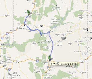
Kaibab National Forest/Grand Canyon:North Rim/Vermillion Cliffs/Glen Canyon/Flagstaff

A couple of spectacular drives out of Utah (a state I was sad to leave): traveling south along Route 89 to Kaibab National Forest (yes, Arizona has pine trees and mountains) onto a road leading to the northern rim of the Grand Canyon, and moving through a desert on Route 89 that paralleled the Vermillion Cliffs. The latter almost rivaled the Scenic Byway from Bryce Canyon a couple of days earlier, and it was pretty amazing. In fact, on the ride back from the byway, I stopped at a filling station in a town called Tropic, and while paying for the gas, I remarked to a local resident about my excitement of traveling on Route 12 for the first time. To which he succinctly remarked, "To me, every time I travel on that road, it's always different."

Kaibab National Forest opened onto a meadow that stretched for miles before reaching the entrance of the Grand Canyon. You can view that area of the canyon from the Grand Canyon Lodge, which has been in operation since 1928. Note to self is to go back there, with a designated driver, and have a few beers at the the Lodge's bar and at the Roughrider Saloon. (NB: since the trip's start, I've actually not had any alcoholic beverage.)

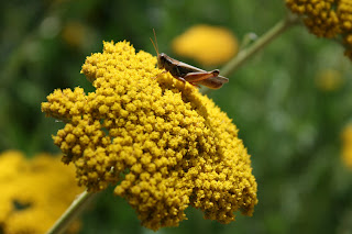
Back on Route 89 toward Flagstaff, the road opened into a valley (still at about 5,000 feet) and a seemingly endless view of red stone known as the Vermillion Cliffs. At the visitor center of Kaibab National Forest, a diagram explained all the different colors of stone at various parks including Zion's white, Bryce's pink and Grand Canyon's chocolate, but more on that another time.

I was impressed by the long stretch of red stone. A detour to Glen Canyon brought me up close to massive boulders that stood on pedestals, and these stones are almost the size of a small house. I drove down to the river. While the temperature was a dry 102 degrees Fahrenheit, the touch of the river was refreshingly cool.

Of course, there was just so much to tell that I've skipped on a lot of details. Maybe a few beers in NYC, I can tell you all about it.

Total trip to Flagstaff, Arizona was 389 miles.

Friday, August 13, 2010

Sunsets

This has been my typical view of a sunset after driving for about 12 to 13 hours on the road. Pretty spectacular, huh? It sure beats being indoors. Each night has been unique -- different shades of yellow, orange, red and the occasional purple. It's as if Mother Nature were painting gradually before my eyes, with the sky as her canvas.

I'll look back on these nights fondly. The sun setting behind a chain of mountaintops. The last remaining rays glowing over hay fields. The sun right in front of my eyes as I push westward through the Great Plains of South Dakota.

Fun times, indeed.

Day Seventeen -- Zion/Bighorn/Kobol Canyons


Lots of new stuff today. One of the major highlights was witnessing a pair of wild bighorns in the canyons of Zion National Forest, which is about an hour and a half's drive southeast of Cedar City. The goal was actually to spend time in a section of the canyons of Zion, but the only outlet for private cars in the park was a road leading out, through a 1.1 mile tunnel. Only buses were allowed to ferry people on that northern trail of Zion.
Eventually I didn't make it to those canyons, but viewing the sheep compensated for that. (I had planned a trip to Bighorn Canyon in Montana to get a glimpse of bighorns, but that won't be necessary!) What also made up for that shortfall was the trip through Kobol Canyons, which is about 30 miles northwest from the entrance of Zion. Early evening sunshine brought out the deep red hue of the canyon, which was spectacular, and with not a cloud in the sky.
After two days in Cedar City, tomorrow's trip is Grand Canyon. And after that hopefully a venture to Monument Valley.

Thursday, August 12, 2010

Day Sixteen -- Canyons


Bryce Canyon/Scenic Byway 12/Escalante/Red Canyon


Great weather, colorful canyons, an impressive drive -- what more could you ask for. It would take days, at least a week, to fully appreciate what this region of Utah offers.

First step from Cedar City was a drive through Dixie National Forest, which reaches an elevation of about 8,000 feet. Then a descent through Red Canyon and oonto the next national park, Bryce Canyon.

Bryce, with its unusual rock formations, reminded me of the Badlands of South Dakota except this area had spectacular shades of red and orange. It was worth traveling along the rim of the canyon and on the hiking trails. I had ventured about half a mile into a hike toward some of the stone formations, but the hike back up was tiring. It was hot and I was breathing heavily. The workout showed how unfit I had become the past couple of weeks because of the many hours of driving and relative inactivity. I miss my bike, which I will hop back onto as soon as I return to NYC.

Anyway, there are many more trails to cover, and it'd be worth traveling back to Bryce, even for a long weekend.

After Bryce, with the clock at 5:30 p.m. and winding down toward sunset, the plan was to travel back along the Route 12 Scenic Byway and get as far as possible with enough time to head back at a decent hour to Cedar City. It was worth the trip because one stretch of the oil-slick road opened into a valley, and that photo in this blog shows how amazing the view was. Driving eastward as the sun set was ideal, and if you do this trip, you'll appreciate how the light plays a factor on this travel.

Escalante has the petrified forest and I only made it as far as the cove near the parking lot of a camping area, before heading back. It would have taken a couple of hours further to complete the route. I'll have to save that for another time.

Wednesday, August 11, 2010

Day Fifteen -- Utah


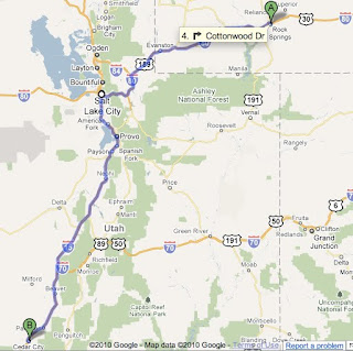
Utah/Salt Lake City/Cedar City

I don't have much photos for this leg of the trip, simply because it was a commute from one city (Rock Springs, Wyoming) to the next (Cedar City). The 430-mile drive lasted about 10 hours, with stops including Salt Lake City at this store called Pictureline Inc. to replenish my stock of 120 millimeter film for the Holga cameras because I've used about 30 rolls of the 120 mm film that I purchased in New York. And in anticipation of really great weather and blue sky I bought five rolls of negative slide for cross-processing.
Tomorrow will be an early start to travel around Bryce Canyon, and the road winds around 230 miles. That means 230 miles of spectacular views of red rock.

Check out these photos from the National Park Service:
http://www.nps.gov/brca/photosmultimedia/photogallery%2Ehtm?eid=133109&root_aId=94#e_133109

The sunset over the mountains near Cedar City, which is about 200 miles northeast of Las Vegas, was pretty amazing. A soft orange glow and the silhouette of mountains by the Great Basin. The Rocky Mountains extends to this area, and the past two days' travel traversed the length of the range for about 1,000 miles from northern Montana/southern Alberta. I don't think I've traveled as far by car along a natural landscape such as this. Maybe on the way back east, to New York, the Appalachian Trail might be worth doing.

One of the quirks of Interstate 15 was the speed limit. Apparently the Utah Department of Transportation is experimenting with an 80 mile-per-hour maximum speed for stretches along the highway, which is the highest I've seen. I don't think a 5 mph difference is significant. There's not much difference between 75 mph and 80 mph because your vehicle's going fast, no matter what. And with few highway patrol vehicles along this road, drivers tend to go fast regardless of the limit imposed. Even in Montana, drivers will push their vehicles to 80 mph, and that seems to be an unwritten rule.

From Park City, a suburb of Salt Lake City, the temperature was 73 degrees Fahrenheit, which isn't unusual because the elevation of that place was about 6,700 feet above sea level. The drive down from the mountain was pretty amazing -- winding roads and no need to push the accelerator, just brake when needed. Reaching Salt Lake City, though, the temperature climbed to 93 degrees but with very little humidity.


Tuesday, August 10, 2010

Day Fourteen -- More Glaciers


Cody/Scenic Route/Yellowstone/Grand Teton

One goal on the return south from Glacier National Park was a stop in Cody, Wyoming, which typified life of the Wild West. A stop at the B
uffalo Bill Historical Center was necessary. The museum highlighted the Cowboy lifestyle, the environment of the Plains and the lives of the Plains Indians. It's worth visiting, and the cafeteria served Sloppy Joes, too.
After Cody the scenic drive to Yellowstone was transformative in landscape terms -- from desert-like conditions and canyons of red rock to lush vegetation and white rock. The drive also accomplished another feat -- traveling through all of the five entrances of Yellowstone National Park, this time entering from the east and leaving the southern gate toward Grand Teton National Park.

I was worried that the rainy weather would cause me to travel through Grand Teton another day, but luckily the weather broke on the approach to the park. That was enough time to get some shots of sunshine near the mountain peaks. The cloudy weather actually helped with diversity in the photographic sense , because I had too many shots of peaks in sunshine. We'll see how the shots turn out after the black and white film's developed.

Total travel time was about 13 hours on about 450 miles.

Monday, August 9, 2010

Day Thirteen -- Cowboy Country


You know you're in cowboy country when tumbleweed tumbles by. Montana has a diverse landscape -- from the Rocky Mountains including Glacier National Park to the prairies of the Great Plains. In between is the desert-like conditions, and Highway 310 is pretty amazing. About 20 miles separate the nearest towns, so if your car breaks down, you're pretty much screwed. And there's no state patrol vehicles, which means you can go as fast as you like beyond the 70 mile per hour speed limit.
Along the highways and streets of towns, Montana has an advertisement campaign against the use of meth, or methamphetamine. Slogans include "Meth Sucks" and "Meth Kills", and these remind me of New York City's campaign in the 1980s against crack use.
And there are plenty of casinos, at gas stations, convenience stores, bars and restaurants. Las Vegas, Atlantic City, American Indian reservations and riverboats don't have a monopoly on betting.
Montana's nickname is Big Sky, but Windy State should be added because there's a lot of crosswinds on the highways, and you can feel the force of the wind push the car sideways.
Today's drive time from St. Mary, the eastern side of Glacier, to Powell, Wyoming was 10 hours with 450 miles covered.
Tomorrow, heading toward Cody, that scenic pass into the eastern gate of Yellowstone, and then southward to Grand Teton National Park.

Saturday, August 7, 2010

Day Twelve -- Ice, Lakes & Canada


Glacier National Park/Waterton Lakes
Finally, the trip to Glacier National Park was coming to fruition. Unfortunately, a haze filled the sky because of smoke from forest fires in Idaho and British Columbia. So I had to make do with the smoke, less than ideal for taking photographs.
The drive along the Going-to-the-Sun highway was pretty good, but not quite as spectacular as the Beartooth Highway Pass. Maybe it was because there were too many vehicles on the road, and the first drive through a glacial pass leaves a strong impression that can't be beat -- almost like remembering first impressions of individuals because they always last.
If it were a clearer day, maybe it would have mattered more. So, maybe that view will change should I travel back here another time. Hopefully before all the glaciers are forecasted to disappear by 2020 as a result of global warming, according to the National Parks Service.
After the 50-mile drive, the natural decision was to drive to the Canadian side of the glaciers, an area known as Waterton Lakes. With passport in hand, the drive took about 90 minutes, and it was worth the short travel. The view overlooking the lakes was better than the U.S. side, because the haze wasn't as obvious.
As a bonus, three cubs and an adult bear happened to be traveling by, and that just added to the list of wild animals -- bison, elk, deer, horses, prairie dogs and chipmunks!