Wednesday, December 22, 2010
Friday, December 17, 2010
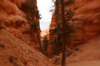
Route 12 Toward Escalante

(Her Photos, Not Mine.)
After Bryce, we headed toward Escalante, where there's an area of petrified wood. That meant traveling back  along my favorite scenic highway: Route 12. Even though it was early afternoon and the sun hid behind the clouds, the view of the mountains and cliffs was spectacular -- just as I had first viewed them months ago. And my friend also found the views breathtaking, uttering "Wow" once in a while.
along my favorite scenic highway: Route 12. Even though it was early afternoon and the sun hid behind the clouds, the view of the mountains and cliffs was spectacular -- just as I had first viewed them months ago. And my friend also found the views breathtaking, uttering "Wow" once in a while. It really felt refreshing to return to a place I had longed to visit. For months, I had envisioned driving back to this place and view once again, those spectacular sights and the road that never seemed to end. It was a matter of wanting, and I wasn't disappointed. I looked toward my fellow passenger and said, "Life feels complete. Thank you for joining me on this travel!"
As we moved eastward, the sky turned darker behind us, and we had to get to the petrified forest area as soon as we could -- winding through the cliffs and massive rock formations of yellow, white and grey.
Our hike through the petrified forest wound through a trail that led us about 300 feet up from the parking lot and gave us a nice view of the valley and Escalante. There were a bunch of logs that were exposed, and I'm sure that there are many specimens of petrified wood beneath our feet. The trail looped back toward the parking lot, and we booked our asses out of there to beat the inclement weather. But that was too late anyway. (Before we left Esacalante Petrified Forest State Park, I left $1 in an envelope as fee for the privilege of hiking the trail. It's actually $5, but the dollar was the smallest bill on hand!)
Snowfall started halfway toward Bryce, and became heavier by the time we reached Bryce, which amused my friend because it was the first time she had seen snowfall accumulate on a wide open field such as the high desert we were in. Indeed, it did feel like winter and snow on the pine trees gave an atmosphere of Christmastime. As we descended, from 6,000 feet, snow turned to sleet, then to rain. By the time we reached Kanab, the town was as dry as a sober man without alcohol for a month.
Wednesday, December 15, 2010
Bryce Canyon


Three months ago, when I first visited Bryce, the weather was about 90 degrees Fahrenheit with the full brunt of the sun's rays. In late November, it's 50 degrees cooler and cloudy.
At the checkpoint, I asked the ranger, "What's the weather like?" His immediate response: "Wind. Snow. Cold." Enough said.
At Sunrise Point, I took my friend by the shoulders and said in front of her face, "So, are you ready for the first day of the rest of your life?" To which she just smiled and offered no response.
We started on the route I had started three months ago, on the trail that led to Queen's Garden. But we took a different path that led to Peekaboo Loop, for a total of about 4 miles. At an elevation of more than 6,000 feet, the ranger wasn't kidding when he said wind was a factor in today's temperature, which felt as if we were freezing. "Oh well, hello winter!" That's all I had thought.
The cooler weather and clouds brought another dimension to viewing the spectacular sights of Bryce Canyon, and later on we would get a dose of snow in the afternoon. The trail leading up to Thor's Hammer was winding and while the view may be better from atop looking downward, the hike up was great.
Monday, December 13, 2010
Kanab, November 20
Our road trip/hiking adventure began Nov. 19 in Vegas, and we would return here 10 days later.
My friend and I left at about 7 p.m. for Kanab, Utah, with a rental all-wheel drive vehicle and enough water and sundries to fill our bellies for the many days of hiking ahead. The plan was to secure hiking passes to this spectacular sedimentary rock formation known as The Wave. As the park ranger told me, we had to be present at the ranger station in Kanab at about 8:45 a.m. to participate in a lottery that would hand out 10 walk-in passes to hikers. She said that about 20 to 30 hikers were present each day, so I figured that staying in Kanab for a couple of days would increase our odds of winning passes for the hike if we didn't get any on the first try. We arrived at our hotel in Kanab at about 11 p.m. (There was a restaurant stop about 50 miles north of Vegas for dishes of fried catfish [hers] and chicken-fried steak [mine]. And the moonlight formed silhouettes of huge mountains in Arizona that we would get to see in daylight on our return trip to Vegas.)
At 8:15 a.m. the next day, I asked the woman at the counter about the distance from the hotel to the ranger station. She said it wasn't far but remarked that she thought the ranger station was closed on weekends (a statement that immediately perked up my ears.) We went to the station, and lo and behold, it was closed on weekends! Thinking it was a mistake we headed back to the hotel and returned at 9 a.m. to see if they were really closed. Upon the return, a ranger passed by the office and informed us that the tickets for The Wave, in the North Coyote Buttes were handed out on Fridays for hikes on Saturdays and Sundays. So, the next chance to bid would be on Monday. So much for my planning. But she let us inside the station and said that there were alternative hikes nearby. She pointed out the petroglyphs by the Coral Sands and a set of fossilized dinosaur tracks not far from Kanab. So, we took her advice and planned for one of those trips on the 21st.
But our first destination was Bryce Canyon and hike. We left Kanab immediately after meeting with the ranger, and it was a good 70-minute drive to Bryce. My friend remarked on the drive northward how the scenery reminded her of home in Australia, with the barren red rock formations and desert plants. All that was missing was a kangaroo.
Catching Up

I know. I haven't submitted an entry since the end of my journey in August. There's a lot to write about, and I am playing catch-up. In the ensuing months from my last blog, I traveled to Canada, to a cousin's lakehouse for a bit of fishing, hiking, boating and barbecuing. I also hiked on some trails in the Lower Hudson Valley. And I ventured south to North Carolina and Tennessee for some hiking in the Great Smoky Mountains. There were spectacular views in each of those trips, such as the long, scenic drive along the Blue Ridge Highway in North Carolina and the awesome view 1,000 feet high from a peak overlooking the Hudson River. Sitting on a boatdeck in a lake with the sun shining and the sky as blue as the water was also memorable.
Still, I yearned for a return trip to southern Utah -- to travel along Scenic Route 12 that captivated my mind since I first traveled along the first 60 miles (and still does today). There are plenty of new places to visit and areas to see one more time because each trip will always be viewed differently.
When my friend said in late October that she had some vacation days to take by the end of the year, I didn't hesitate to tell her to take some time off and travel across spectacular Utah, because as the state's nickname implies "It's God's country." I had told her of my earlier plans to return there, and I had invited her, but the timing was off during September and October. She said late November would be possible, and I said it might be cold so prepare for wintry conditions. And so when she asked me to travel with her, I didn't hesitate.
So, to go back, at the penultimate night of that trip, on August 19, I ate at a Chinese restaurant, and a fortune cookie revealed itself to say this, in not-so-perfect English: "Ask a friend to join you on you[r] next voyage."
Wednesday, August 18, 2010
Day Twenty-Two -- Cahokia
Cahokia
So, I made it to Cahokia Mounds, near East St. Louis, for the first time since 1990 when I was an archaeology student. Being here brought back fond and fun memories. I didn't make it to Hannibal, though, which is a shame since I recall some good times there, too. But, oh well, that will have to wait another time.
In Terre Haute, Indiana -- one day away from NYC. But this won't be the end of this journey. Still more to come...
Tuesday, August 17, 2010
Blog Title
Some of you may wonder what is the meaning behind the blog's title. My sister-in-law told me before the trip that I would be a road warrior. So, to take advantage of that I decided to make it up in Ilongo -- hangaway (haang-ga-WHY) for warrior and dalan (DAH-laan) for road, and combining the two as hangaway sa dalan (warrior of the road).
I know, it does sound morbid if you read it as Hang away sad Alan. That reminds me of a name of a road in metro Manila: Singalong (sin-GAH-long).
Subscribe to:
Posts (Atom)