Friday, April 1, 2011

Day One


Our hike took twice as long as it should have because my gait was slow. We set camp by the stream. So many climbs/descents to chronicle in one day.
We set out at 10:40 a.m. from the trailhead. The trail was relatively flat until we got to Appalling Face. Took me about an hour and a half to scramble down the rock face, when it should have been fewer. (Remember, it is a 50 percent slope.) Pretty agonizing. I had a couple of slides from the face, and it was a bit unnerving each time. I've been told we have to make it out on the third day within the allotted 10-hour time limited. Otherwise, we will have to turn back, which I dread.

Returning on the ledge at the side of the canyon with 50 pounds on my back isn't ideal. I don't want to return on that route, which is a major incentive to complete the third day's hike.

After completing the descent from Apalling Face, I was constantly falling back. At one point, Jason and Daniel were searching for me because I turned at the wrong fork of the trail. Still, even with the wrong route I met them by a stream. And we continued our journey toward the canyon.

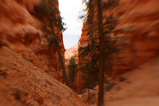
We crisscrossed the stream and eventually had to work our way up a 10-foot high ledge. Jason chose one route, and all of us (being that we were two) followed. My hands gripped tightly on some rocky edges, otherwise a slip meant certain injury or even death. We hiked higher along the canyon's trail until we could no longer see the stream -- just rocky ledges. And our trail was narrow, too.

I was last man back, but it was tiring, and I was always careful not to trip. Otherwise, a slip there, too, meant certain death. But about an hour and a half from our start at the 10-foot high ledge, I reached Jason and Daniel, who were setting up camp by the stream.

Dinner was prepared by Jason: spaghetti with tomato sauce and served alongside cheese-filled hot dogs. Daniel showed me how to pump water from the stream through a filter and into our water bottles. Pretty amazing stuff.

In spite of the lower weight from the food we just ate, my worry is that my load will remain the same because of the filled water bottles.

Darkness sets in at around 7:45 p.m. Total trip was about 7 hours on what should have been a 4-hour hike.


Dark

Road Trip to Utah from Ohio, March 17-18


I arrived at Cincinnati airport at about 7:30 p.m. from New York City's LaGuardia Airport. Jason and Daniel picked me up, and we immediately drove toward Utah. We drove across the flat lands of Kentucky, Indiana, Illinois, Kansas before reaching the mountains of Colorado and Utah -- more than 1,500 miles in about 30 hours. Unusually, I remained a passenger throughout the entire trip because I wasn't one of the designated drivers on the rented Chevrolet Cruze sedan.

Jason probably slept a total of three hours during the drive to Dark Canyon Wilderness. We were pulled over in Kansas because the state trooper thought that I was a child sleeping in the rear and he noticed the car moving in and out of the painted yellow line on the left. No ticket there, though.

We had our assortment of road trip junk food: Wendy's hamburgers, Krispy Kreme doughnouts (at least for me), Pringles chips, Pepsi soda. And a hamburger or chicken burger and two pints of beer (for Jason) at Ray's Tavern in Green River, Utah.

We arrived close to midnight at the Sundance trailhead, which is probably about 5,000 feet above sea level. The moon was so bright that you could make out the bottom of the canyon. The Bureau of Land Management says that the talus slope, or slope characterized by piles of rock, is 50 percent, or about 27 degrees. But it sure looks steeper than that.

Wednesday, March 30, 2011

Return to Utah

My latest travel has taken me to Cincinnati, where I would meet an old friend from high school whom I have not seen since 1989. We had kept in contact over the years. And a few months ago, he invited me to travel with him for a backpacking trip in southern Utah's Dark Canyon Wilderness. The prerequisites for the trip required me being sufficiently fit and having no fear of heights. I was definitely in shape for the trip and I have no fear. Period.

I am lifting comments directly from my daily journal entries into this blog. So, I make no apologies for grammar, and my elocution won't exactly match that of a Boston Brahmin's. I usually wrote at night under a headlamp in the tent, so with pencil in hand my scribbles couldn't be edited.

I'm glad to have made this trip. It was my first backpacking adventure, and it proved to be extremely challenging -- mentally AND physically. I learned a lot from this trip and knew my limitations. But I could always push myself further. And I wouldn't hesitate to repeat this particular hike. After all, learning is through experience.

Friday, December 17, 2010

Route 12 Toward Escalante


(Her Photos, Not Mine.)
After Bryce, we headed toward Escalante, where there's an area of petrified wood. That meant traveling back along my favorite scenic highway: Route 12. Even though it was early afternoon and the sun hid behind the clouds, the view of the mountains and cliffs was spectacular -- just as I had first viewed them months ago. And my friend also found the views breathtaking, uttering "Wow" once in a while.

It really felt refreshing to return to a place I had longed to visit. For months, I had envisioned driving back to this place and view once again, those spectacular sights and the road that never seemed to end. It was a matter of wanting, and I wasn't disappointed. I looked toward my fellow passenger and said, "Life feels complete. Thank you for joining me on this travel!"

As we moved eastward, the sky turned darker behind us, and we had to get to the petrified forest area as soon as we could -- winding through the cliffs and massive rock formations of yellow, white and grey.

Our hike through the petrified forest wound through a trail that led us about 300 feet up from the parking lot and gave us a nice view of the valley and Escalante. There were a bunch of logs that were exposed, and I'm sure that there are many specimens of petrified wood beneath our feet. The trail looped back toward the parking lot, and we booked our asses out of there to beat the inclement weather. But that was too late anyway. (Before we left Esacalante Petrified Forest State Park, I left $1 in an envelope as fee for the privilege of hiking the trail. It's actually $5, but the dollar was the smallest bill on hand!)

Snowfall started halfway toward Bryce, and became heavier by the time we reached Bryce, which amused my friend because it was the first time she had seen snowfall accumulate on a wide open field such as the high desert we were in. Indeed, it did feel like winter and snow on the pine trees gave an atmosphere of Christmastime. As we descended, from 6,000 feet, snow turned to sleet, then to rain. By the time we reached Kanab, the town was as dry as a sober man without alcohol for a month.

Wednesday, December 15, 2010

Bryce Canyon


Three months ago, when I first visited Bryce, the weather was about 90 degrees Fahrenheit with the full brunt of the sun's rays. In late November, it's 50 degrees cooler and cloudy.

At the checkpoint, I asked the ranger, "What's the weather like?" His immediate response: "Wind. Snow. Cold." Enough said.

At Sunrise Point, I took my friend by the shoulders and said in front of her face, "So, are you ready for the first day of the rest of your life?" To which she just smiled and offered no response.

We started on the route I had started three months ago, on the trail that led to Queen's Garden. But we took a different path that led to Peekaboo Loop, for a total of about 4 miles. At an elevation of more than 6,000 feet, the ranger wasn't kidding when he said wind was a factor in today's temperature, which felt as if we were freezing. "Oh well, hello winter!" That's all I had thought.

The cooler weather and clouds brought another dimension to viewing the spectacular sights of Bryce Canyon, and later on we would get a dose of snow in the afternoon. The trail leading up to Thor's Hammer was winding and while the view may be better from atop looking downward, the hike up was great.


Monday, December 13, 2010

Kanab, November 20

Our road trip/hiking adventure began Nov. 19 in Vegas, and we would return here 10 days later.
My friend and I left at about 7 p.m. for Kanab, Utah, with a rental all-wheel drive vehicle and enough water and sundries to fill our bellies for the many days of hiking ahead. The plan was to secure hiking passes to this spectacular sedimentary rock formation known as The Wave. As the park ranger told me, we had to be present at the ranger station in Kanab at about 8:45 a.m. to participate in a lottery that would hand out 10 walk-in passes to hikers. She said that about 20 to 30 hikers were present each day, so I figured that staying in Kanab for a couple of days would increase our odds of winning passes for the hike if we didn't get any on the first try.
We arrived at our hotel in Kanab at about 11 p.m. (There was a restaurant stop about 50 miles north of Vegas for dishes of fried catfish [hers] and chicken-fried steak [mine]. And the moonlight formed silhouettes of huge mountains in Arizona that we would get to see in daylight on our return trip to Vegas.)
At 8:15 a.m. the next day, I asked the woman at the counter about the distance from the hotel to the ranger station. She said it wasn't far but remarked that she thought the ranger station was closed on weekends (a statement that immediately perked up my ears.) We went to the station, and lo and behold, it was closed on weekends! Thinking it was a mistake we headed back to the hotel and returned at 9 a.m. to see if they were really closed. Upon the return, a ranger passed by the office and informed us that the tickets for The Wave, in the North Coyote Buttes were handed out on Fridays for hikes on Saturdays and Sundays. So, the next chance to bid would be on Monday. So much for my planning. But she let us inside the station and said that there were alternative hikes nearby. She pointed out the petroglyphs by the Coral Sands and a set of fossilized dinosaur tracks not far from Kanab. So, we took her advice and planned for one of those trips on the 21st.
But our first destination was Bryce Canyon and hike. We left Kanab immediately after meeting with the ranger, and it was a good 70-minute drive to Bryce. My friend remarked on the drive northward how the scenery reminded her of home in Australia, with the barren red rock formations and desert plants. All that was missing was a kangaroo.